

How Satellites Track Autumn Leaf Colour—and What It Shows
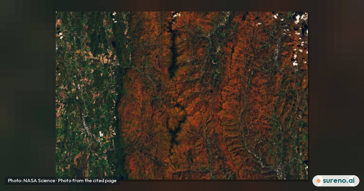
NASA’s PACE satellite measures light reflected by vegetation to follow autumn color changes across forests.
The short version
- NASA’s PACE satellite measures reflected light in many narrow wavelength bands, helping scientists track changes in autumn leaf pigments. 1
- Those measurements can show where forest color is changing and when the color peak occurs. 1
- The observations track the balance of red, orange, and yellow color relative to green; they do not simply photograph leaves as people see them. 1
- The supplied NASA source describes sample maps for two weeks in early autumn, but does not provide enough detail here to interpret specific locations or later seasonal patterns. 1
How do satellites track autumn leaf color?
NASA’s PACE satellite carries an instrument called OCI, short for Ocean Color Instrument. Despite its name, OCI also observes vegetation. It measures reflected light across 286 spectral bands—narrow portions of the light spectrum—every day. 1
Some of those bands help scientists detect subtle changes in pigments in leaves. Rather than relying only on a view that resembles an ordinary photograph, researchers can compare the measured signals associated with different pigments. 1
What do changing leaf pigments tell scientists?
Leaves contain pigments that contribute to their color. NASA’s account identifies anthocyanins with reds, carotenoids with yellows and oranges, and chlorophylls with greens. 1
Scientists can use the satellite measurements to follow how the amount of red, orange, and yellow in forests changes compared with green. Looking at that ratio over time can indicate where leaves are changing and when color reaches a peak. 1
What does a satellite autumn-color map show?
The NASA page presents maps comparing vegetation “redness” from September 29 to October 4 and from October 5 to 11. The description says areas shown in green have values near 1, but the supplied material cuts off before fully explaining the map’s scale. 1
That means the maps are best understood as measurements of vegetation color signals over time, not as a simple guide to the brightest viewing spots. The source excerpt does not give enough information to explain every map color or identify particular places where peak color occurred. 1
Why observe autumn leaves from space?
A satellite can observe vegetation across broad areas repeatedly. In this case, PACE’s daily observations let scientists follow seasonal color changes across forests rather than relying only on individual viewpoints. 1
The observations can help describe where change is happening and when it peaks. They provide a way to monitor a seasonal pattern at large scale, though the supplied source does not detail how scientists validate these measurements against observations on the ground. 1
What can satellite leaf-color data not tell us?
A color signal alone does not explain why a particular forest changed when it did. The NASA source explains how pigment-related measurements can track change, but the material provided does not establish causes for any specific place or season. 1
A separate research record provided here concerns artificial light and autumn leaf aging in urban areas, but it contains only a title and publication details, not findings. It therefore cannot support a claim about how lighting affected the maps described by NASA. 2
What we don't know yet
- The supplied NASA excerpt does not fully explain the map scale or all of its color values. 1
- It does not report specific locations where autumn color peaked or provide a complete account of the season’s results. 1
- The source material does not explain how the satellite measurements were checked against observations on the ground. 1
Share this explainer
New discoveries on every new tab
Sureno Browser puts explainers like this one on your start page every morning, in plain words.
Questions people ask
Can satellites see fall foliage?
Satellites measure light reflected by vegetation, and some measurements can track changes in leaf pigments linked to autumn color. NASA says PACE’s OCI observes vegetation daily, allowing scientists to follow those changes over time. 1
What is NASA PACE measuring in autumn leaves?
PACE’s Ocean Color Instrument measures reflected light across 286 spectral bands. Some wavelengths help scientists track signals associated with red, yellow, orange, and green leaf pigments. 1
How can scientists tell when fall color peaks?
They can compare the measured amounts of red, orange, and yellow in forests with green over time. NASA says tracking this ratio can reveal where leaves are changing and when color peaks. 1
Do satellite maps show the best places to see fall colors?
The maps described by NASA show vegetation color measurements, not necessarily a list of the best places for visitors. The supplied source excerpt does not identify specific viewing locations or fully explain every map value. 1
What leaf pigments create autumn colors?
NASA’s account links anthocyanins with red, carotenoids with yellow and orange, and chlorophylls with green. The satellite instrument can track subtle changes in signals associated with these pigments. 1
Sources
- Hunting Red Leaves with Satellites - NASA Science — NASA Science, 2026-10-26
- Increased artificial illumination delays urban autumnal foliar senescence. — Nature communications, 2026 Jan 3
Free tools for this
They run in your browser. Nothing is uploaded and there is nothing to sign up for.
More to read
 ScienceHow Scientists Trapped a Positron for MonthsOct 23, 2026 · 3 min read0 views
 ScienceWhat biodiversity means for cities, oceans and ecosystemsOct 22, 2026 · 5 min read0 views
 ScienceHow Excess RNA May Disrupt Cells’ Energy SupplyOct 21, 2026 · 3 min read0 views
 ScienceWhat Recent Research Says About Climate and Air PollutionOct 21, 2026 · 4 min read0 views
 Tech & Online SafetyThree limits of today’s AI: confidence, decisions and languageOct 25, 2026 · 5 min read1 view
 ScienceHow Kelvin Waves Can Raise Pacific Sea LevelsOct 20, 2026 · 3 min read0 views
 ScienceThree studies test cleaner power’s reach, materials and claimsOct 20, 2026 · 6 min read0 views
 ScienceHow New Methods Could Reduce Animal TestingOct 19, 2026 · 4 min read0 views
 ScienceWhat Dogs’ Bouba-and-Kiki Responses May Tell UsOct 19, 2026 · 4 min read0 views
 MoneyJackdaw Gasfield Approval: What It Means for UK EnergyOct 21, 2026 · 4 min read3 views