Drought-Fueled Fires Char New Guinea, NASA Science Shows Record Papua New Guinea Emissions
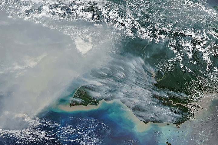
Smoke spreads across New Guinea
New Guinea is the world’s second-largest island and includes tropical rainforests, savannas and swamp forests. During September and October 2026, drought associated with a strong El Niño set the stage for fires, and smoke covered large areas for weeks.
The VIIRS instrument aboard the NOAA-20 satellite captured smoke streaming from the island’s southern region on October 11, 2026. High pollution levels delayed or canceled flights and closed schools. Officials in some areas urged children and older people to wear masks. Robert Field, a research scientist at NASA’s Goddard Institute for Space Studies and Columbia University, said some smoke is washed out or lifted by thunderstorms, while much remains near the surface and harms air quality. He called the situation “horrible.”
Emissions reach exceptional levels
On the Indonesian side of the island, carbon emissions topped 35 megatons, the third-highest level after 2015 and 1997. Both were El Niño years marked by severe fires.
GFED estimates fire extent and emissions using satellite observations, vegetation characteristics and other information. Its record spans nearly three decades.
Drought and human-set fires
El Niño shifted rainfall patterns and left ecosystems unusually dry. In the Trans-Fly region of southern Papua New Guinea, more than 90 consecutive days passed without rain, according to the country’s National Weather Service. Some areas received only about 5 to 10 percent of normal precipitation from August onward.
Researchers say people ignite most fires in this normally wet region. Common reasons include crop burning, pasture upkeep, land clearing, deforestation and hunting. Under dry conditions, fires intended for land management can escape and become uncontrolled, especially in the island’s south. Local news outlets reported that drought was contributing to crop failures, water shortages and school disruptions.
Forest loss and regional differences
Yang Chen, an associate researcher at the University of California, Irvine, said fire activity was especially high this year in Papua New Guinea and eastern Indonesia, including Indonesian Papua and Kalimantan. He described Papua as Indonesia’s “new deforestation frontier.” Over the past two decades, land in Indonesian Papua has been cleared for oil palm and pulpwood plantations, small-scale cultivation, urban growth and mining. Global Forest Watch reported that the region lost 27,000 hectares of primary forest in 2025, nearly twice the 2024 figure and the largest loss since 2017.
Key points
- Smoke from fires covered large parts of drought-stricken New Guinea for weeks in 2026.
- Papua New Guinea’s estimated emissions reached nearly 32 megatons of carbon by October 17.
- Indonesian Papua’s emissions exceeded 35 megatons, the third-highest level on record.
- Dry conditions can turn people’s managed burns into uncontrolled wildfires.