How NASA Science Tracked an Extratropical Cyclone Whipping Past Iceland After Explosive Intensification
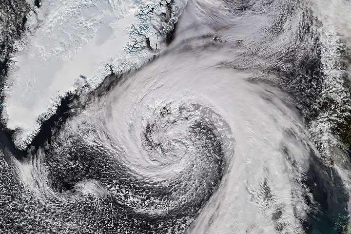
From hurricane remnants to cyclone
The system developed into an extratropical cyclone, a low-pressure storm often marked by comma-shaped clouds. Such storms can produce hurricane-force winds, heavy rain and blizzard-like conditions.
Rapid pressure drop over ocean
NOAA-21’s VIIRS instrument captured the cyclone brushing Iceland on the afternoon of October 14. Reports said its air pressure plunged by more than 50 hectopascals over 24 hours, approximately double the criteria for explosive cyclogenesis, also called bombogenesis.
High winds hit Iceland and Scotland
The cyclone grazed Iceland’s coast, bringing high winds. A gust of 205 kilometers (128 miles) per hour was recorded near Eyjafjallajökull volcano in the south, and a small island offshore recorded sustained winds of 150 kilometers (93 miles) per hour.
Damaging winds reached northern Iceland, where residents also prepared for sleet and snow. Northwestern Scotland recorded gusts up to 90 kilometers (55 miles) per hour on October 14, and several ferry routes were canceled, according to news reports.
Satellite image and reporting
The image was produced by NASA Earth Observatory’s Michala Garrison using VIIRS data from NASA EOSDIS LANCE, GIBS/Worldview and the Joint Polar Satellite System. Lindsey Doermann wrote the story.
Reports describe the storm as a possible record-breaker, not a confirmed record. The reported pressure change and wind observations show the cyclone’s strength as it crossed the North Atlantic.
Key points
- Isaias’s remnants became an extratropical cyclone over the North Atlantic.
- NOAA-21 captured the storm near Iceland on October 14.
- Pressure fell by more than 50 hectopascals in 24 hours.
- Iceland and northwestern Scotland experienced damaging winds and travel disruption.