

What an Early Polar Vortex Disruption Could Mean for Winter
The vortex has weakened unusually early, but that does not make snow or severe cold a sure thing in the US or UK.
The short version
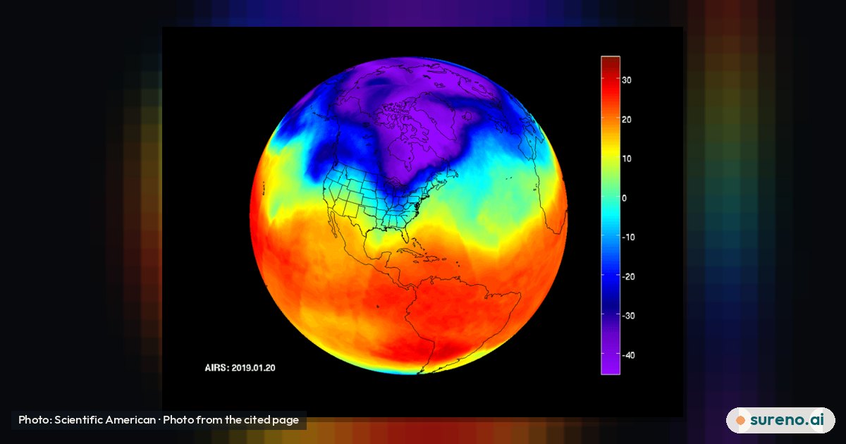
- The polar vortex is a circulation of cold air and strong winds high above the Arctic; it has weakened unusually early this November, according to reports 12.
- A disruption can change the winds high in the atmosphere and, in turn, shift the jet stream, the fast-moving current of air that helps steer weather 2.
- That can raise the chance of colder Arctic air reaching parts of North America or Europe, but it does not guarantee snow or a cold spell in any particular place 12.
- Because this event is so early, there are few past cases to compare with, making its effects difficult to forecast 2.
What is the polar vortex?
The polar vortex is a large circulation of cold air around a pole. In winter, the stratospheric version above the Arctic is encircled by strong westerly winds. The stratosphere is a layer of the atmosphere roughly 10 to 30 miles above Earth's surface 12.
The vortex is not the same thing as the cold weather people experience at the ground. The stratospheric circulation and the weather closer to Earth's surface are distinct, even though changes high above can sometimes influence weather below 23.
What does an early disruption mean?
The vortex has weakened and shifted position unusually early in the season. Atmospheric disturbances can warm air high in the stratosphere, weakening the vortex winds. If the winds reverse direction, that is known as a sudden stratospheric warming, or SSW 2.
Reports describe this November event as unprecedented in modern observations or potentially the earliest of its kind on record. The sources also stress that there are few historical examples this early in the season, so the exact significance is difficult to judge 12.
How could it affect US and UK weather?
Changes in the stratosphere can influence the jet stream in the days and weeks that follow. A shifted jet stream may help create a blocked weather pattern, which can bring drier conditions and allow colder northerly or easterly winds to carry Arctic air into parts of Europe. Similar disruptions have sometimes been followed by colder weather in parts of Europe and North America 12.
These are possibilities, not a local forecast. A polar vortex disruption does not by itself tell us whether a particular US state or the UK will get snow, how cold it will become, or when any change might arrive. The reports describe uncertainty about the effects of this unusually early event 2.
Does this mean snow is on the way?
No. A weakened vortex may raise the chance of weather patterns that bring colder air to some areas, but that is not the same as predicting snow. The outcome depends on how the atmospheric changes develop and affect the jet stream; the available reporting does not establish a definite snow forecast for the UK or the US 12.
For a place-specific outlook, check forecasts from the relevant national weather service or a trusted local forecaster. Those forecasts address conditions nearer the ground and can be updated as the situation develops.
Why is the forecast especially uncertain?
Polar vortex disruptions can occur in winter, but this one is happening unusually early. With few comparable events from this point in the season, past patterns offer limited guidance about what will happen next 2.
The sources establish a weakening and possible atmospheric effects, not a precise timeline or a guaranteed outcome for any region. Forecasts may change as meteorologists learn how the stratospheric circulation and the jet stream respond 12.
What we don't know yet
- How the weakened vortex will evolve over the coming days and weeks.
- Whether the changes will significantly shift the jet stream.
- Which areas, if any, will see a lasting period of colder weather.
- Whether the disruption will bring snow to particular parts of the US or UK.
Share this explainer
Get this every day, on every new tab
Sureno Browser brings the day's stories, explained simply, to your start page.
Questions people ask
What is happening to the polar vortex?
Will the polar vortex bring snow to the UK?
It is too early to say that it will. A disruption can affect the jet stream and increase the chance of colder northerly or easterly winds, but it does not guarantee snow in the UK 2.
Could the polar vortex bring cold weather to the US?
What is a sudden stratospheric warming?
It is a warming of air high in the stratosphere that can weaken the polar vortex winds. In some cases, the strong westerly winds can reverse into easterly winds, with possible effects on the jet stream 2.
Sources
- The polar vortex is about to go haywire — Scientific American
- Could the earliest weakening of the polar vortex on record bring UK snow? — BBC Weather
- Polar vortex — Wikipedia
More to read
 Nature & AnimalsHow Forecasters Track Possible Atlantic Storm DevelopmentNov 6, 2026 · 3 min read0 views
 Nature & AnimalsHow Octopuses Squeeze Through Tiny OpeningsNov 6, 2026 · 3 min read0 views
 Travel & PlacesIs Ryanair introducing a 60-minute bag-drop rule?Nov 8, 2026 · 3 min read0 views
 Travel & PlacesHow to Choose a Travel Backpack That Fits Your NeedsNov 8, 2026 · 3 min read0 views