

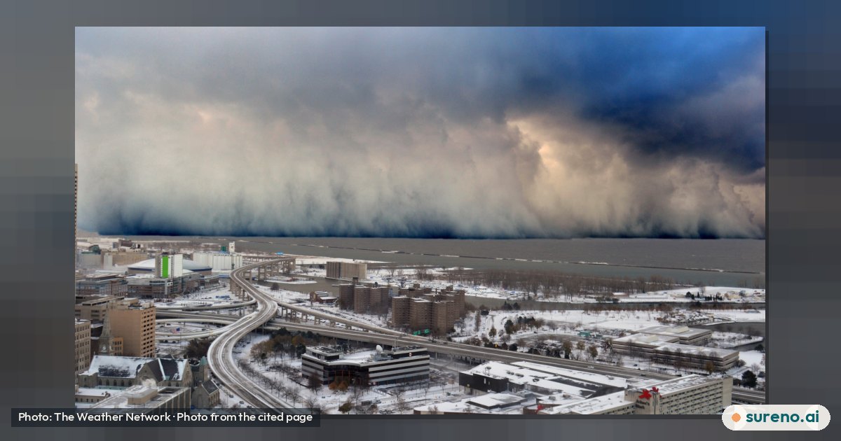
Buffalo’s 2014 Snowstorm: Why It Was So Severe
A rare combination of cold air, warm lake water and strong winds produced intense, sharply localized snowfall around Buffalo.
The short version
- Buffalo’s November 2014 snowstorm was severe because very cold air moved over relatively warm Great Lakes water, while strong southwesterly winds directed a concentrated snow band toward Buffalo’s southern suburbs. 1
- The event came in back-to-back lake-effect bursts over four days, and some communities received more than two metres of snow. 1
- Snowfall varied sharply over short distances: a 2014 retrospective contrasts a light dusting in Buffalo and its northern suburbs with nearly seven feet in the Southtowns and areas east of the city. 2
- The sources describe major disruption, including blocked roads, stranded residents and a large emergency response, but do not provide enough detail to make a complete local preparedness guide. 13
Why was Buffalo’s 2014 snowstorm so severe?
The main cause was a setup that favored lake-effect snow. Cold air flowed over the Great Lakes, which were still relatively warm. The contrast added heat and moisture to the air, helping snow clouds develop. A strong low-pressure system over Ontario and Quebec helped draw the cold air across the lakes. 1
Over Lake Erie, strong southwesterly winds pushed a particularly heavy snow band toward Buffalo’s southern suburbs. Snowfall rates briefly approached 15 centimetres an hour, and thunder and lightning were reported. 1
How much snow fell, and where was it worst?
The storm did not cover the Buffalo region evenly. The Weather Network reports that some communities received more than two metres from the back-to-back squalls. A later account describes nearly seven feet in the Southtowns and areas east of the city, compared with only a dusting in Buffalo and its northern suburbs. 12
That sharp boundary is characteristic of a lake-effect snow band: one area can be buried while a nearby area gets much less. The sources do not give a complete set of snowfall measurements for every community, so those examples should not be treated as a full regional total map. 12
What happened during the storm?
The first intense band began affecting Buffalo-area suburbs on the evening of November 17, 2014. Heavy snow continued through November 18 and eased by the morning of November 19, according to The Weather Network’s account of that burst. 1
Accumulations clogged roads and rose over many vehicles. Emergency declarations were made, and the broader storm brought emergency crews and the National Guard into the response. A storm summary reports that people were stranded in homes and cars were buried. 13
Why can one Buffalo neighborhood get much more snow?
Lake-effect snow forms in narrow, organized bands rather than spreading like an even blanket. Wind direction helps determine where a band travels. If it stays over one area, that place can accumulate heavy snow while locations outside the band receive far less. The 2014 accounts show how pronounced that contrast was around Buffalo. 12
The available sources describe the winds and the contrasting snowfall, but they do not provide a detailed neighborhood-by-neighborhood account of how the band shifted during the full event.
What can residents learn from the 2014 storm?
The history offers a practical lesson about uncertainty: a regional forecast cannot tell every household exactly how much snow its street will receive. A narrow band can make conditions very different within a short distance. 12
The storm also shows why road disruption and being stranded matter in a lake-effect event. For current forecasts, travel conditions and preparation guidance, residents should check official weather and emergency-management sources. The research provided here does not document a detailed checklist or establish which specific preparations made the greatest difference in 2014.
What we don't know yet
- The sources do not provide a complete, verified snowfall total for every affected community.
- They do not give a detailed timeline showing how the snow band shifted across each neighborhood during the entire event.
- The material provided does not document a full evaluation of the storm response or a tested household-preparation checklist.
Share this explainer
Get this every day, on every new tab
Sureno Browser brings the day's stories, explained simply, to your start page.
Questions people ask
What caused the Buffalo snowstorm in November 2014?
Very cold air moved over relatively warm Great Lakes water, helping create lake-effect snow. Strong southwesterly winds carried a particularly intense band off Lake Erie toward Buffalo’s southern suburbs. 1
How much snow did Buffalo get in 2014?
Why did Buffalo get more snow than nearby areas?
When did the 2014 Buffalo snowstorm happen?
What does the 2014 storm teach about preparing for lake-effect snow?
It shows that snowfall can differ sharply between nearby places and that roads can become clogged during an intense band. For current forecasts and practical preparation guidance, consult official weather and emergency-management sources; the research provided does not supply a detailed checklist. 12
Sources
- The wild squall that dropped 2+ metres of snow in four days - The Weather Network — The Weather Network, 2026-11-17
- A paralyzed Buffalo, a daring rescue and the November storm of 1974 | From the archives — JournalStar.com
- November 13–21, 2014 North American winter storm — Wikipedia
Free tools for this
They run in your browser. Nothing is uploaded and there is nothing to sign up for.
More to read
 Tech & Online SafetyApple’s November 17 Outage: Services and Next StepsNov 18, 2026 · 3 min read0 views
 Tech & Online SafetyWhy Congress Is Questioning Nvidia’s China SalesNov 18, 2026 · 3 min read0 views
 Tech & Online SafetyApple Service Outage: What Users and Developers Need to KnowNov 18, 2026 · 4 min read0 views
 SpaceDid Curiosity Find Elemental Sulfur Inside a Mars Rock?Nov 17, 2026 · 3 min read0 views